Recent Earthquakes in California and Nevada
Long Valley Special Map
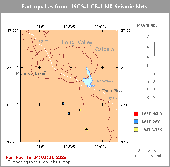
Click on an earthquake on the above map for more information.
Update time = Mon Nov 16 04:00:01 2026
Here are the earthquakes appearing on this map, most recent at top ...
| MAG | LOCAL DATETIME y/m/d h:m:s |
LAT deg |
LON deg |
DEPTH km |
LOCATION |
| 2.2 | 2026/11/15 22:01:38 | 37.505N | 118.872W | 4.72 | 17 km (11 mi) SSE of Mammoth Lakes, CA |
| 1.8 | 2026/11/15 19:38:37 | 37.459N | 118.844W | -0.69 | 23 km (14 mi) SSE of Mammoth Lakes, CA |
| 1.8 | 2026/11/14 18:34:48 | 37.390N | 118.754W | 12.09 | 27 km (17 mi) W of West Bishop, CA |
| 2.0 | 2026/11/14 03:42:53 | 37.460N | 118.845W | 7.08 | 23 km (14 mi) SSE of Mammoth Lakes, CA |
| 2.4 | 2026/11/14 00:35:07 | 37.475N | 118.783W | 11.33 | 25 km (15 mi) SE of Mammoth Lakes, CA |
| 1.2 | 2026/11/13 22:59:00 | 37.475N | 118.781W | 9.14 | 25 km (16 mi) SE of Mammoth Lakes, CA |
| 1.6 | 2026/11/12 16:20:34 | 37.461N | 118.840W | -0.32 | 23 km (14 mi) SSE of Mammoth Lakes, CA |
| 1.4 | 2026/11/12 05:14:37 | 37.384N | 118.745W | 1.59 | 26 km (16 mi) W of West Bishop, CA |

[
Index map ||
Big earthquake list ||
All earthquake list ||
Glossary of terms ||
Top page
]
[
Did you feel it? ||
ShakeMaps
|| Relative2Me
]
[ Data Sources ]
Special maps
Long Valley || Los Angeles || San Francisco
Data Sources
US and World - USGS/NEIC = National Earthquake Information Center
Northern California - UCB = University of California, Berkeley
Southern California - Caltech = California Institute of Technology
Nevada - UNR = University of Nevada, Reno
Offshore = West Coast & Alaska Tsunami Warning Center
...all members of the Advanced National Seismic System (ANSS)


