Recent Earthquakes in California and Nevada
Los Angeles Special Map
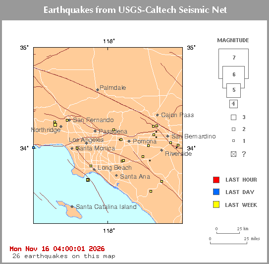
Click on an earthquake on the above map for more information.
Update time = Mon Nov 16 04:00:01 2026
Here are the earthquakes appearing on this map, most recent at top ...
| MAG | LOCAL DATETIME y/m/d h:m:s |
LAT deg |
LON deg |
DEPTH km |
LOCATION |
| 1.5 | 2026/11/16 01:53:07 | 34.004N | 118.872W | 5.62 | 6 km ( 4 mi) W of Malibu, CA |
| 0.9 | 2026/11/15 14:34:53 | 34.001N | 117.192W | 12.81 | 6 km ( 4 mi) S of Redlands, CA |
| 2.0 | 2026/11/14 23:34:48 | 34.230N | 118.615W | 3.77 | 3 km ( 2 mi) SSW of Chatsworth, CA |
| 0.9 | 2026/11/14 06:10:06 | 34.161N | 117.432W | 5.99 | 7 km ( 5 mi) SSW of Devore, CA |
| 1.8 | 2026/11/14 00:39:02 | 33.680N | 118.237W | 3.36 | 8 km ( 5 mi) SE of San Pedro, CA |
| 1.3 | 2026/11/13 20:28:16 | 34.026N | 117.172W | 13.87 | 3 km ( 2 mi) SSE of Redlands, CA |
| 1.2 | 2026/11/13 15:09:56 | 33.915N | 117.585W | 17.57 | 4 km ( 2 mi) WSW of Norco, CA |
| 1.0 | 2026/11/13 12:12:30 | 33.566N | 117.493W | -0.53 | 2 km ( 1 mi) SSE of Quarry at ELS (Probable quarry explosion) |
| 0.5 | 2026/11/13 06:25:18 | 34.104N | 117.427W | 5.91 | 3 km ( 2 mi) ENE of Fontana, CA |
| 1.2 | 2026/11/13 06:20:30 | 34.053N | 117.264W | 16.25 | 1 km ( 0 mi) NNW of Loma Linda, CA |
| 2.5 | 2026/11/12 18:11:54 | 33.681N | 118.234W | 7.84 | 8 km ( 5 mi) SE of San Pedro, CA |
| 1.3 | 2026/11/12 13:23:16 | 34.177N | 117.933W | -0.91 | 22 km (14 mi) NNW of Quarry at POMONA (Probable quarry explosion) |
| 0.9 | 2026/11/12 13:18:28 | 33.873N | 117.507W | -0.48 | 3 km ( 2 mi) NNW of Quarry at CORONA (Probable quarry explosion) |
| 1.1 | 2026/11/12 09:19:46 | 33.667N | 117.364W | 9.20 | 3 km ( 2 mi) W of Lake Elsinore, CA |
| 1.0 | 2026/11/12 08:33:27 | 34.082N | 117.841W | 13.44 | 2 km ( 1 mi) S of Charter Oak, CA |
| 1.6 | 2026/11/12 06:22:04 | 34.022N | 117.522W | 8.73 | 3 km ( 2 mi) N of Mira Loma, CA |
| 1.1 | 2026/11/12 01:06:34 | 33.873N | 117.812W | 15.60 | 2 km ( 1 mi) S of Yorba Linda, CA |
| 1.1 | 2026/11/11 20:35:39 | 34.216N | 117.465W | 10.36 | 6 km ( 4 mi) SSE of Lytle Creek, CA |
| 1.3 | 2026/11/11 15:28:28 | 33.867N | 117.832W | 10.25 | 3 km ( 2 mi) SW of Yorba Linda, CA |
| 1.6 | 2026/11/10 17:53:23 | 33.999N | 118.363W | 6.14 | 1 km ( 1 mi) ESE of Baldwin Hills, CA |
| 1.0 | 2026/11/10 11:39:08 | 34.129N | 117.460W | 8.12 | 4 km ( 2 mi) N of Fontana, CA |
| 1.2 | 2026/11/09 23:05:49 | 34.219N | 117.422W | 12.58 | 2 km ( 1 mi) W of Devore, CA |
| 1.7 | 2026/11/09 18:06:03 | 34.271N | 118.478W | 10.54 | 2 km ( 1 mi) E of Granada Hills, CA |
| 1.1 | 2026/11/09 09:41:24 | 34.256N | 118.625W | 6.00 | 2 km ( 1 mi) W of Chatsworth, CA |
| 0.6 | 2026/11/09 09:26:32 | 34.081N | 117.859W | 12.49 | 3 km ( 2 mi) SSW of Charter Oak, CA |
| 1.5 | 2026/11/09 05:41:27 | 33.821N | 118.198W | 10.21 | 3 km ( 2 mi) WNW of Signal Hill, CA |

[
Index map ||
Big earthquake list ||
All earthquake list ||
Glossary of terms ||
Top page
]
[
Did you feel it? ||
ShakeMaps
|| Relative2Me
]
[ Data Sources ]
Special maps
Long Valley || Los Angeles || San Francisco
Data Sources
US and World - USGS/NEIC = National Earthquake Information Center
Northern California - UCB = University of California, Berkeley
Southern California - Caltech = California Institute of Technology
Nevada - UNR = University of Nevada, Reno
Offshore = West Coast & Alaska Tsunami Warning Center
...all members of the Advanced National Seismic System (ANSS)


